Stories / South America / Chile |
||||
|
[ Rain, Snow, and a Group of Chilean High School Girls | Page 2 ]
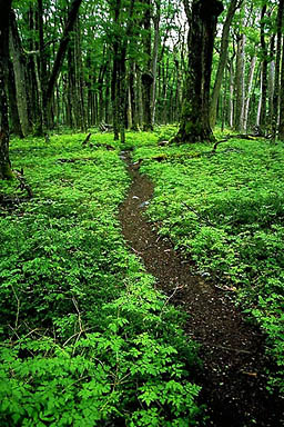
“Why am I here?” I ask myself, yet again, wading through a swamp of ankle-deep mud. It’s cold and raining. It’s been raining for the last two days—nonstop. My clothes are soaked through; my boots are soaked through, my feet blistered. The trail continues to follow the wide valley of the Rio Paine for several hours. We reach Refugio Dickson in the early afternoon to find a small wooden hut with an old stove and a handful of wet, weary hikers taking shelter from the rain. Some are determined to continue the circuit, while others are already turning back. But we can’t turn back. We force our way up a steep, slippery path, through dense foliage and wet branches that snap and scatter puddles of water as we pass. When the trail levels out, we enter a dark forest of tall, ancient trees and become enveloped in a green canopy of leaves, moss and grass. The trail leads to a lookout over a small waterfall, then continues up the valley, weaving around massive tree trunks that seem to have intentionally fallen to block our path. The steady rain is our faithful companion. As we gain altitude, it turns to sleet, then snow. We arrive at Camparmento Perros in a blizzard. The camp is located on small lake at the foot of a gray glacier that snakes up into the fog. Blocks of ice break off from the glacier to form icebergs that drift across the lake. Some of the trekkers we meet have been camping here for days or even a week, waiting for the weather to improve. But we don’t have enough food to wait. We must cross the pass tomorrow or turn back and retrace our steps down the valley. The pass is snowbound and it’s still snowing as I drift into an uneasy sleep. —————— It’s still snowing when we wake the next morning. A foot of fresh snow has fallen overnight and a thick fog hangs in the air. I light our stove to boil some water for breakfast. At the next campsite, a group of trekkers is waking to another disappointing morning. They’re staying put for one more day, but we’ve decided to press on. With limited visibility, we rely on vague footprints in the snow to find the trail, but these become increasingly difficult to follow as they fill with falling snow. When the footprints disappear, we follow a loose trail of orange ribbons, wrapped around distorted tree trunks and tied to twisted branches. As we climb higher through the sparse forest, these markers become more sporadic. Within an hour we’re standing in a labyrinth of stunted trees, lost, looking for clues. I circle around to scan the area. The ribbons have vanished. The footprints are gone. Even our own footprints, behind us, are rapidly fading with the falling snow. “We’ve lost the trail,” I remark casually, as my eyes meet Rahul’s to silently acknowledge the gravity of the situation. I nervously pull a map from my pack, but there are no landmarks to find our position, just snow and trees and fog. My finger traces the broken red line of the trail on the contour map as it traverses the side of a narrow valley from Camparmento Perros to the John Gardner pass. Slowly, it dawns on us. We’re on the wrong side of the valley. The distant muted roar of the Rio de los Perros guides us back down into the valley. On the other side, a half hour later, we finally rejoin a vague trail of footprints. We continue to climb higher into a white nebula of snow and fog. Soon, we’re above the tree line and catching up with a pair of hikers in the distance. As we get closer, we suddenly realize that they’re coming toward us. “We’re turning around,” explains one of the men, worn-out and obviously disappointed, “the snow is knee-deep up there and you can’t see a thing. Maybe we’ll try again tomorrow if the weather improves. Good luck.”
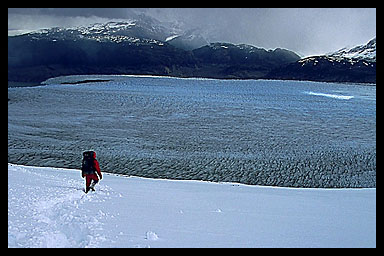
Their tracks continue for another twenty or thirty minutes, and then end abruptly. “This must be where they turned around,” I observe, taking off my pack and dropping it in the snow. We take a break for a few minutes to consider our options. Where do we go from here? It’s only another hour or two to the pass, but it won’t be easy to find the trail. We’ve already lost our way once. At least the snow is starting to subside and some the clouds are lifting. Could the weather be improving? As I scan the horizon, I spot an enormous orange-painted boulder in a distant snowfield high above us. It’s the trail. With renewed enthusiasm, we alternate breaking trail through the fresh snow that reaches ankle-deep in some places, waist-deep in others. I kick a step in the snow, rest, and kick another step. A numbing wind whips my face. “Kick, step, rest. Kick, step, rest.” I repeat to myself to keep the rhythm, to keep moving, to keep my mind off the cold and the fatigue. By the time we reach the orange boulder, we can finally make out the pass in the distance. We continue to climb, making slow but measured progress. The snow slope gradually levels out as we approach the pass and we’re greeted by a howling gale that threatens to knock us over. I brace myself against the wind and impulsively scramble up the last few steps. And then, I’m standing on the John Gardner pass, encircled by a ring of jagged, icy peaks. Far below, on the other side of the pass, the Grey glacier is an infinite sea of ice stretching toward the Patagonian icecap. We’ve made it. “Remember, we’re only halfway,” cautions Rahul. But we begin our descent knowing that worst is behind us, and I'm already dreaming about a hot shower and a comfortable bed when I return to Puerto Natales. |
||||
Related Links |
||||
Tell me what you think about this story Read more travel stories See more photos from Chile and South America Lonely Planet guide and map for Chile Concepto Indigo is an excellent guide service based in Puerto Natales. They also run a very comfortable hostel that's popular with trekkers and mountaineers on their way to the park. GORP is another good source of information on Torres del Paine National Park. |